WASHINGTON COUNTY HISTORICAL SOCIETY (Washington County, Utah)
THE HONEYMOON TRAIL
(a history)
Cultures at a Crossroads, An Administrative History of Pipe Spring National Monument
by Kathleen L. McKoy
2000
The Honeymoon Trail
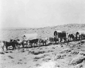
Once peace was made with the Navajo, Latter-day Saints began colonizing along the Little Colorado River in Arizona. A ferry was established across the Colorado at the mouth of the Paria where both Jacob Hamblin and John Wesley Powell had found a feasible crossing. John D. Lee, in hiding for his role in the Mountain Meadows massacre, moved to this remote site with one of his wives, Emma, in December 1871. By January 1873, Lee offered regular ferry service to travelers seeking to cross the river and the place became known as "Lee's Ferry." Brigham Young issued a call that year for colonists to go to Arizona and fill the Little Colorado Mission. The missionaries - 109 men, 6 women, and 1 child - gathered at Pipe Spring, beginning the trek in 54 wagons. The wagon trail traveled nearly 200 miles, creating a rough road as it went. Historian C. Gregory Crampton describes their route to Lee's Ferry:
From the open valley of Kanab Creek the colonists wound along the ledgy, rocky western slope of the Kaibab Plateau. On top they had to traverse a thick forest of pinyon and juniper which snared animals and tore canvas. Then they jolted and bumped down the eastern slope of the Kaibab, which was steeper than the western slope. Through House Rock Valley and along the base of the Vermilion Cliffs they pulled through deep sand, headed washes and deep gulches, and finally arrived at the mouth of the Paria.Once they made the difficult crossing at Lee's Ferry, the first band of colonists had only a horse trail to follow along a steep and rugged rock crest known as "Lee's Backbone." Wagons had to follow switchbacks over a talus slope covered with sandstone blocks, then made their way southward along the base of the Echo Cliffs. Wagons continued into side canyons opening into Marble Canyon, through washes, barren hills, and across the Painted Desert until they reached Moenkopi, where they found spring water. Moenkopi was only 70 miles from Lee's Ferry, but the trek took the band 26 days, attesting to the ruggedness of the terrain. Proceeding on to the Little Colorado River, the settlers found a bleak and barren region with the riverbed nearly dry. Believing no settlement could be established in such a place, they headed back over the route just traversed.
Still, the road had been opened to the Little Colorado, soon to be traveled by a scouting party in 1875 and another mission of 200 men, organized in 1876. The settlers in this latter mission reached Sunset Crossing, near present-day Winslow, Arizona, in March 1876. Between 1876 and 1880, the Utah-Arizona road was in constant use as Latter-day Saints streamed into the Little Colorado region, establishing a foothold in northeastern Arizona. Beyond Lee's Ferry the route was known as the Mormon Wagon Road. By 1880 two other routes were used by Latter-day Saints traveling between Utah and the Little Colorado River settlements in Arizona, although neither was as heavily traveled as the Lee's Ferry route.
Once the St. George Temple was completed in 1877, young Mormon newlyweds, married by civil authorities in the Arizona settlements, traveled from the Little Colorado River settlements to St. George (by way of the Mormon Wagon Road and Lee's Ferry route) to have their vows solemnized in the temple. Generally, several wagons traveled together, providing both companionship and security in case problems were encountered along the primitive road. C. Gregory Crampton reports these treks were usually made in mid-November with the couples remaining in St. George for the winter, returning to the Little Colorado in April. The route was traveled by so many newlyweds that it came to be known popularly as "The Honeymoon Trail."
Portions of the old road's well-worn trace can still be seen, including at the vicinity of Pipe Spring where late 19th century travelers would have naturally stopped for water. A portion of the Honeymoon Trail is shown on early 20th century area maps as the "Kaibab Wagon Road" as it passes through the Pipe Spring vicinity. Once Pipe Spring National Monument was established, a number of changes were made to the small section of historic road that traversed the 40-acre tract. In 1934 the road was relocated south of the fort ponds; it was abandoned altogether as a vehicular route, once State Highway 389 opened in 1967. While native vegetation now obscures much of the old road trace within the monument itself, it can be very easily discerned as one looks southwest far across the landscape from the fort.