WASHINGTON COUNTY HISTORICAL SOCIETY (Washington County, Utah)
HIGHWAY 91
ROUTE

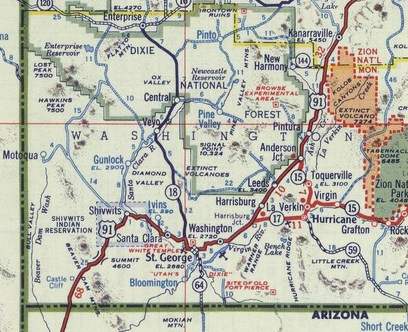
US Highway 91 (now called Old Highway 91) came over the mountain from Beaver Dam AZ into Utah. It passed through Santa Clara and followed what is now Sunset Blvd. into St. George at the north end of the Black Hill.
Originally, it went down down Diagonal Street to Main Street. Then it followed Main Street down to Tabernacle where it turned east and followed Tabernacle to the east end of town. From there it curved up and went through the Washington Tunnel.
Later, its path through St. George was rerouted (as noted below) to follow what is now SR-18 (Bluff Street) south. Then it curved through what is now the Hurst-Ace Hardware property. It then continued east on 100 North (what is now St George Blvd.; see the 1961 map). From 900 East, it curved diagonally northeast toward the Washington Tunnel and through the hill.
From there it headed diagonally over to what is now Telegraph Road in Washington. It followed what is now Telegraph Road up to and across Highway 9. About 2.5 miles north of Highway 9, Old Highway 91 currently becomes a dirt road for a little less that 2 miles. Continuing on, it passes through Leeds on what is now Main Street (Highway 228). Old Highway 91 continues north along the east side of I-15 to Anderson Junction), where it is now known as Anderson Junction Road.
About 1.2 miles north of Anderson Junction, the road peters out where it appears it was destroyed by the construction of I-15. It reappears about 0.8 miles further north. Then it continues along the east side of I-15 up to and about a mile beyond Pintura. The roadway is lost there, but roughly followed the current route of the freeway up to Exit 36 (the Black Ridge "Ranch Exit").
From there, it winds around the south and west sides of Ash Creek Reservoir and up through the Harmony Valley, currently using the name Old Highway 91. The current road ends just west of I-15 and just north of Exit 40.
On the east side of the freeway, the old highway becomes Harmony Ridge Drive. The surfaced road ends just before Taylor Creek. But traces of the road continue after Taylor Creek and go north along the east side of I-15. A little wasy before I-15 Exit 42, the road is again paved and continues on up out of Washington County toward Kanarraville.
HISTORY
In 1926, the federal system of numbered highways was initiated, and the Arrowhead Trail became known as US Highway 91. Highway 91 became the principal north-south route through Washington County. In 1931, the final stretch of Highway 91 from Harrisburg through Leeds to Toquerville Junction was paved. US Highway 91 was at its peak from 1947 to 1965. It was superceeded by the I-15 freeway. In 1971, the process was started to drop the US 91 designation. That process was completed by 1974 when all remaining portions of the highway became state highways.Originally, Highway 91 came through St. George by going down Diagonal Street to Main Street. Then it followed Main Street down to Tabernacle where it turned east and followed Tabernacle to the east end of town. From there it curved up and went through the Washington Tunnel.
Sometime, maybe in the 1930s, there was a lot of controversy ending with Highway 91 being rerouted down Bluff Street and across 100 North to the east side of St. George where it then cut up and through the Washington Tunnel.
At some point, the term "Highway 91" was replaced with "Old Highway 91".
Was that change made officially or just in common practice? Was the US 91 designation officially ended?
On January 18, 2022, the name was officially changed to "Old Dixie Highway 91" by Proclamation of the Washington County Commissioners.
REFERENCE
Wikipedia article about Highway 911926 map of the US highway system
Proclamation No. 2022-18 by the Washington County Comissioners
Changed the highway name to "Old Dixie Highway 91", January 18, 2022