WASHINGTON COUNTY HISTORICAL SOCIETY (Washington County, Utah)
THE ROCKVILLE BRIDGE
Rockville, Utah
LOCATION
|
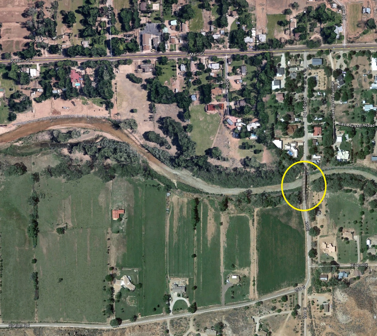
On Bridge Street crossing the East Fork
of the Virgin River (south of Highway 9) Rockville, UT 84763 37° 9' 31.56" North, 113° 2' 15.81" West 37.1588° North, 113.0377° West 3,748 feet (1,142 meters) MSL |
DESCRIPTION
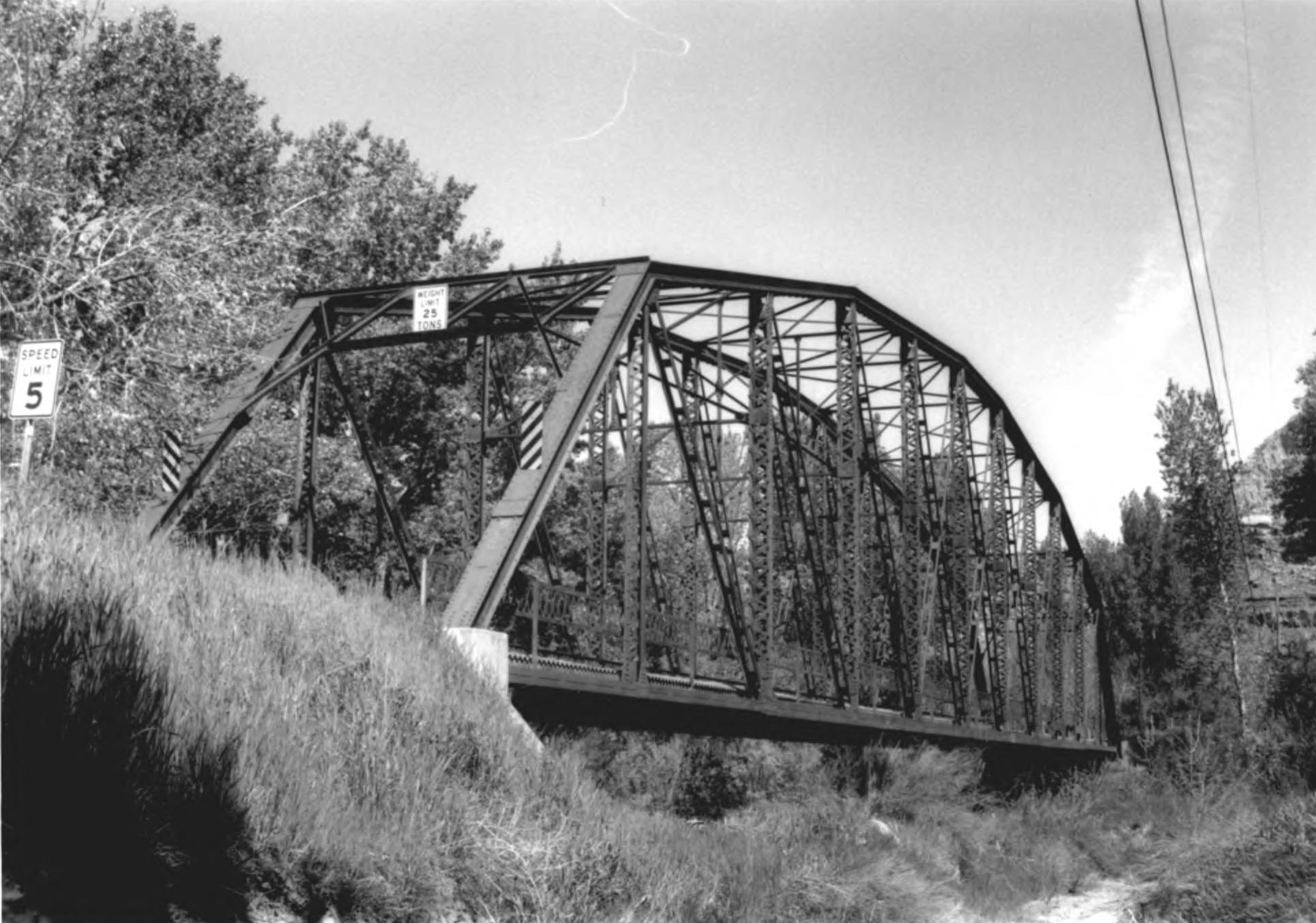
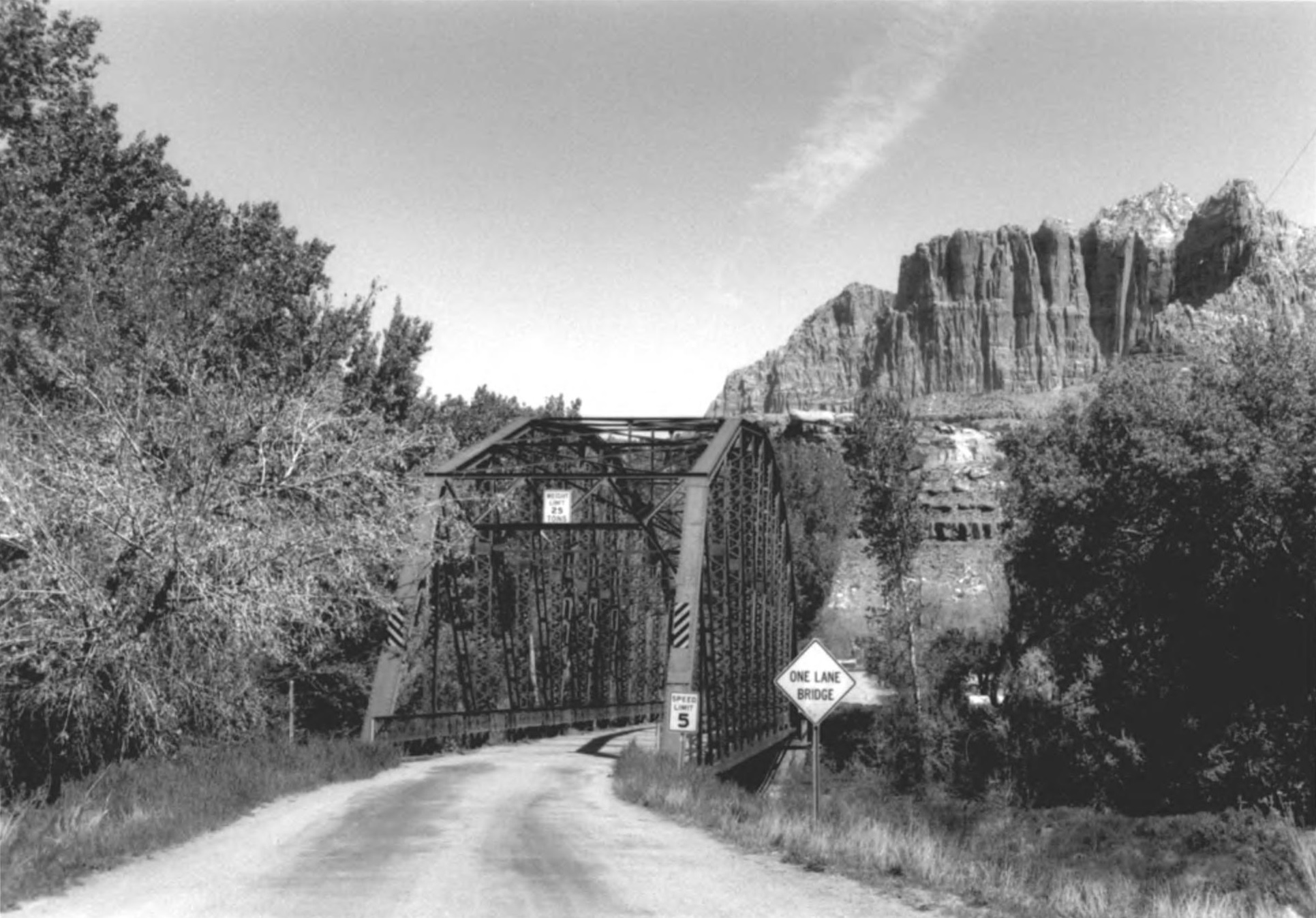
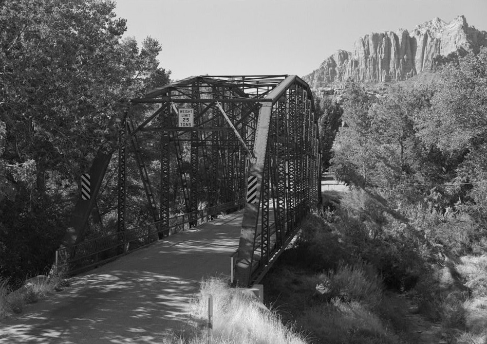
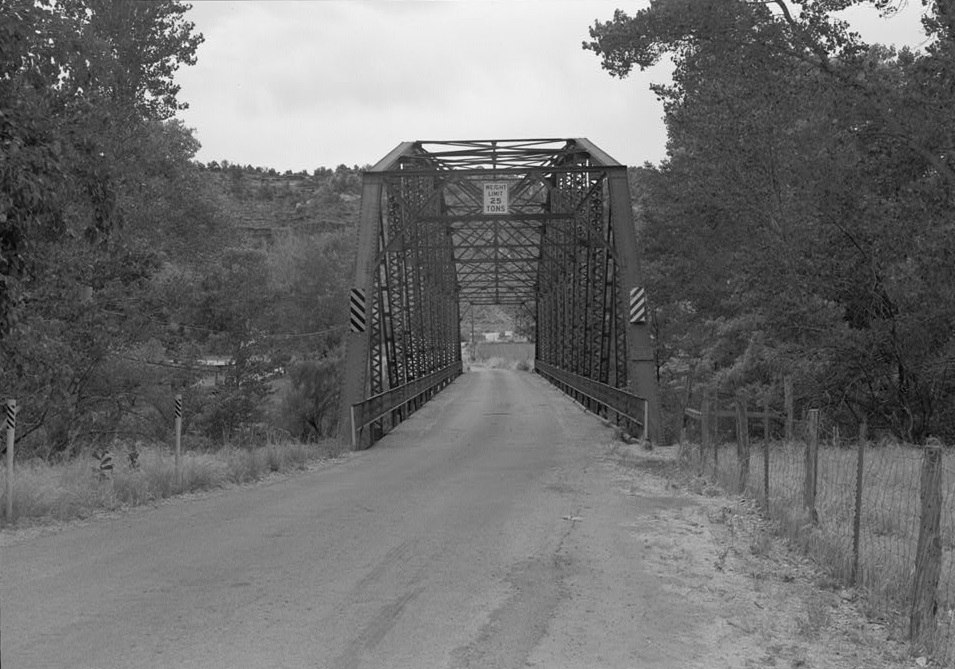
In March of 1923, a federal appropriation of $133,000 for Zion National Park was allocated for survey and specifications of park roads. The appropriation included $40,000 for the construction of a bridge on public land outside the park boundary, crossing the Virgin River near Springdale, Utah. The bridge was to be used to permit a shortcut into Arizona (later known as the Rockville shortcut or Rockville cutoff) with work undertaken during the winter of 1923-1924.The Rockville Bridge was constructed in 1924 and carries a country road (called Bridge Road) just south of Highway 9, across the east fork of the Virgin River on the south side of Rockville, Utah. This 217-foot rigid-connected Parker through truss bridge consists of twelve panels in a single span steel truss supported by concrete abutments. A network of struts and braces connects the top chords for structural support. The asphalt covered concrete deck carries a 25 ton capacity for a single lane of traffic. A builder's plate mounted on the Northwest corner of the bridge states the following:
VIRGIN RIVER
Bridge Built for the
NATIONAL PARK SERVICE 1924
Minneapolis Steel & Machinery Co. Fabricators
C.F. Dinsmore Co. Erectors
The structural and historical integrity of the bridge have been exceptionally well preserved, with no major alterations to date.
HISTORY
Constructed in 1924, the Rockville Bridge is architecturally and historically significant. The bridge incorporates distinctive characteristics in its method of construction and is the only surviving example of a rigid Parker through truss type bridge in the state of Utah. As such, it is one of the most technologically significant transportation spans in the state. In addition to its architectural significance, the Rockville Bridge is historically significant in the region. As the first direct link between Zion National Park and the North Rim of the Grand Canyon, the bridge was built in response to and then contributed to the development of tourism in the area. The Rockville Bridge retains its historic design, material, workmanship, setting, and association.National parks of Southern Utah and Northern Arizona (including Bryce Canyon, Cedar Breaks, the Grand Canyon, Pipe Springs, and Zion National Park) have been very popular among tourists since their discovery by Arizona and Utah settlers in the mid 19th century. In the early 20th century, more people became aware of the parks as a result of a campaign by the Union Pacific Railroad to market the regional parks. Automobile traffic increased throughout the 1910s, and visitors to the region demanded better accessibility to the area. By 1920, when Zion Canyon was officially dedicated as a National Park, local residents and tourists placed heavy pressure on government officials at all levels to develop improved transportation routes and other services in the region.
In the 1920s, the National Park service allocated resources to developing automobile loop-tours that allowed tourists to visit multiple parks in the area without backtracking their routes. The construction of the Rockville Bridge allowed such a circular route to be established from Zion National Park to the North Rim of the Grand Canyon. This popular route directed traffic from Zion National Park south through Rockville to Pipe Spring National Monument (Arizona) and the Grand Canyon. In the 1920s, the Rockville Bridge was an essential link in this concentrated network of national parks. In 1926, daily bus service transported tourists over the Rockville Bridge in a loop tour from Zion National Park south to the Grand Canyon and then north again to Bryce Canyon.
Between 1924 and 1928, the Rockville bridge provided the primary automobile route from Utah's National Parks to the Grand Canyon. This period of significance is derived from the original construction date of the bridge (1924) until the construction of the Zion-Mt. Carmel Highway and tunnel in 1928. The more direct and popular Mt. Carmel route carried traffic east along Highway 9 to Pine Creek and Kanab before heading south to the Grand Canyon. In addition to providing a shorter route to the Grand Canyon, this reliable new highway was easier for drivers to maneuver during inclement weather.
The Rockville Bridge was designed by the U.S. Bureau of Public Roads for the National Park Service. C.F. Dinsmore, an Ogden bridge contractor, erected the bridge on site from prefabricated steel components manufactured by the Minneapolis Steel & Machinery Company. The construction of the Rockville Bridge is summarized in local newspaper articles (Washington County News) published between April and December, 1924:
April 24, 7924;
"Virgin Bridge Awaits Move by Arizona - Until Arizona approves of her portion of the Short Creek route between Hurricane and Fredonia as part of her federal aid road system, the national park system is not eager to build the proposed bridge across the Virgin River at Rockville, for which appropriation was made by the last congress. There is some danger that the appropriation will lapse as a consequence, and the matter has been called to the attention of the Utah congressional delegation by [Utah] Governor Mabey."
May 8, 1924:
"Bridge at Rockville to be Built at Once - Director Stephen Mather of the National Park Service has directed that the contract be let and construction work begin at once on the bridge over the Virgin River near Rockville. The state road commission received this word April 30."
October 73, 7924:
"Steel is now being laid across the new bridge which will be completed in the near future."
December 25, 1924:
"Mr. Dinsmore of the Dinsmore Construction Company and a number of workmen arrived here Friday. Work on the new bridge is progressing finely."
December 25, 7924:
"The new steel bridge spanning the Virgin River at Rockville, erected at a cost of $42,000, will shorten the road from Zion National Park to Grand Canyon by 30 miles. Rockville celebrated the bridge opening on the 13th inst." Metal truss bridges began to replace American wood bridges in the early 1840s; they were the most popular designs between 1850 and 1925. Most of the designs called for the use of many small pieces or members to make a long truss that provided the necessary length and strength. These pieces were commonly manufactured off-site by steel companies and then shipped by railroad to the site where local contractors assembled the bridges. These early metal bridges were of two basic types: Pratt and Warren. The Parker truss, a variation of the Pratt truss, was routinely used for bridges that spanned 40-200 feet. Only two such bridges were constructed in Utah, however: the Rockville Bridge and the Jensen Bridge (demolished in 1994), which crossed the Green River in Uintah county.
The Rockville Bridge is an important architectural and historical resource in Utah. Because it is the only remaining Parker through truss bridge in Utah, the Rockville Bridge holds exceptional technological significance. In addition, the Rockville Bridge was a vital transportation link between Utah and Arizona scenic wonders between 1924 and 1928. The bridge bears a significant contribution to the broad patterns of historical development in the region. Although it no longer carries main traffic over the Virgin River to the Grand Canyon, the Rockville Bridge, today a National Park Service "Scenic Backway," continues to function in place with no major alterations to date. The bridge retains outstanding historic integrity.
Put on the National Register of Historic Places (#1995000982) on August 4, 1995.
PHOTOS
 WCHS-03293 Looking southsoutheast |
WCHS-03294 Looking southeast |
 WCHS-03295 Looking northnorthwest |
 WCHS-03297 Looking south |
Other WCHS photos:
WCHS-03296 Photo of the Rockville Bridge looking southwest
WCHS-03298 Photo of the Rockville Bridge looking northwest
WCHS-03299 Photo details of the Rockville Bridge vertical and diagonal connection
Other photos on the web:
Rockville Bridge structure, December 27, 2008
Rockville Bridge structure around 2009
REFERENCES
Library of Congress, Historic American Engineering Record, Rockville BridgeCall Number: HAER UTAH,27-ROC.VI.V,1-
Survey number HAER UT-74
National Register of Historic Places, Inventory - Nomination Form
Photos from the National Register of Historic Places nomination form, April 1995
Future of historic Rockville Bridge in question
by Dan Mabbutt, St. George News, September 12, 2013
Town leaders seek support for Rockville Bridge rehabilitation
by Reuben Wadsworth, St. George News, February 16, 2017
How a Small Town is Preserving an Historic Treasure - And how you can help!
In Heritage, The Preservation Utah Newsletter, Winter 2017
Rehabilitation of historic Rockville bridge set to begin
by Mikayla Shoup, St. George News, August 30, 2018
Rockville day; from water travails to sorghum production to an iconic restored bridge
by Reuben Wadsworth, St. George News, April 7, 2019
Ribbon Cut on Restored Rockville Bridge
by Kirk Huffaker, Preservation Utah "Saving Places", Summer 2019, Page 2
Rockville holds ceremony to reopen its restored iconic bridge
by Reuben Wadsworth, St. George News, May 4, 2019
Historic Rockville bridge project earns national award for excellence in historic preservation
St. George News, August 7, 2020