WASHINGTON COUNTY HISTORICAL SOCIETY (Washington County, Utah)
CRAWFORD IRRIGATION CANAL
Crawfordville, Utah
LOCATION
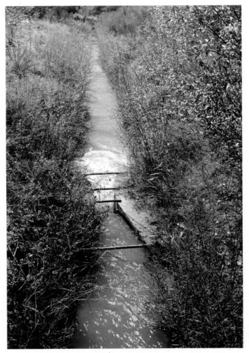
Water was originally diverted from the west bank of the Virgin River (approximately one mile north of the present-day Virgin River Bridge). The point of diversion is marked by a large boulder just upstream from a rock slide on the west bank of the Virgin River. The channel of the canal is outlined by cottonwood trees and brush for most of its approximately 1.5 mile course. The ditch runs south, following the River on its west bank, traverses the base of the Virgin Formation to the northwest of the Visitor's Center, then turns northwest for 0.5 mile up Oak Creek.HISTORY
The Crawford Canal was built by Mormon settlers in Zion whose community of farms in the Oak Creek Canyon was sometimes referred to as Crawfordville. Water was originally diverted from the west bank of the Virgin River (approximately one mile north of the present-day Virgin River Bridge) by moans of a pioneer-built wooden headgate. In 1931, the Oak Creek Canyon farms were purchased the National Park Service which took possession of the water delivery system. In 1933, CCC personnel of Camp N.P.2 widened the Crawford Canal to eighteen inches for a distance of 5,l78 feet. A concrete cyclopean-type diversion dam was installed at the head of the canal on December 23, 1941 by the Park Maintenance Dept.Although the canal is no longer functional, its course is clearly visible. The canal and its system of laterals provided water for livestock and irrigated fields of alfalfa and sorghum.
PHOTOS
Crawford Irrigation Canal
Other photos on the web:
Photos from the National Register of Historic Places nomination form