WASHINGTON COUNTY HISTORICAL SOCIETY (Washington County, Utah)
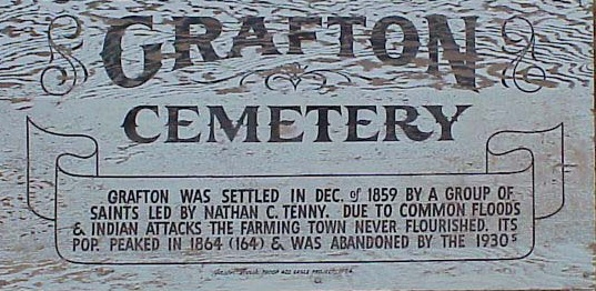
GRAFTON CEMETERY
Grafton, Utah
LOCATION
Grafton, UT37° 9' 47" North Latitude, 113° 4' 48" West Longitude
Elevation: 3704 feet
From Highway 9 in Rockville, turn south on Bridge Road (200 East).
Bare right after crossing the Virgin River.
Turn right again at the stop sign.
The last 2.6 miles are unpaved but should be okay for cars in dry weather.
Grafton's cemetery is on the left at a turn 0.3 mile before the town site.
1900 map of Grafton, including the cemetery.
HISTORY
TBDPHOTOS
Photos on the web:Photo of a Grafton Cemetery sign
Photo of the Grafton Cemetery and sign
Photo of the Grafton Cemetery entrance and sign
Photo of a Grafton Cemetery sign
Photo of the entrance to the Grafton Cemetery
Photo of some graves in the Grafton Cemetery
GRAVES
Plot map of the Grafton CemeteryBurial list from Find A Grave
Burial list from the Utah Gravestones Project
REFERENCES
Grafton Cemetery Burials DataFind A Grave
Washington County, Utah Tombstone Project
Historic Rockville, Utah
Book by Jane E. Whalen, 2012.
Pages 116-117: "1862-1924 Grafton Cemetery"